Thinking about selling your acreage near Council? In this market, buyers judge value by the land first and the house second. They want to grasp access, water, fencing, and usable acres within minutes. This guide gives you a practical staging plan and photo shot list tailored to Council and Adams County so you can present your property clearly and confidently. Let’s dive in.
Why land-first sells in Council
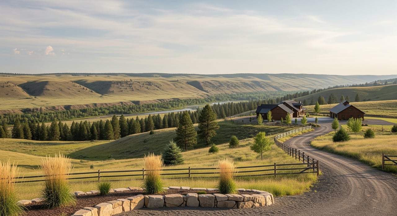
Council sits in a rural corridor where ranchland, timbered hills, small farms, and recreation shape demand. Buyers focus on usable acres, irrigation or well performance, fencing and corrals, winter access, and proximity to public lands. When you make these elements obvious in photos and showings, you help buyers see value quickly.
Local agencies and programs matter during due diligence. Expect questions about zoning and access from Adams County Planning & Zoning, well logs and water rights tracked by the Idaho Department of Water Resources, and wildfire or timber considerations guided by Idaho Department of Lands and nearby federal land managers. Having your documents in order speeds trust and negotiation.
Start with access
Clear, safe access is the first impression and a primary value filter for rural buyers.
Driveways and gates
- Trim approach lines and mow edges so the driveway reads clean and wide.
- Fill or grade ruts and add gravel where needed.
- Repair or replace broken gate hardware. Tidy or remove unrelated signage.
Signage and directions
- If access involves private roads or easements, prepare a simple, labeled map for showings.
- Place temporary, clear directional signs so visitors do not get lost.
Road maintenance and winter notes
- Summarize county versus private road maintenance. Provide copies of road agreements and typical annual costs if private.
- Note plowing arrangements or seasonal closures and keep the driveway photo-ready in winter.
Turnarounds and parking
- Show tractor and trailer turning radii near barns or corrals.
- Mark equipment parking areas so buyers can visualize daily use.
Outbuildings and infrastructure
Outbuildings often carry as much weight as the home in rural sales. Present them as clean, safe, and functional.
Inventory and condition
- Create a one-page inventory: structure type, footprint, year built or last maintained, power and water availability, floor type, and door details.
- Label power as single-phase or three-phase if known.
Clean, declutter, and repair
- Remove unused vehicles, scattered tools, and scrap piles.
- Broom-clean barns and shops; sweep aisles and organize benches.
- Fix visible hazards like broken stairs, torn roofing, and exposed nails.
Highlight working features
- Stage pens with clear gates and working latches.
- Show hay storage capacity and water troughs.
- Photograph functional chutes, corrals, and handling areas to signal readiness.
Make your acres legible
Buyers want to know what each acre does. Help them read the land at a glance.
Define usable acres
- Map and, if possible, physically mark building sites, pasture, timber stands, and riparian zones.
- Be clear about steep or rocky acres versus truly usable ground.
Fencing and paddocks
- Repair visible fence sections near the house and corrals.
- Mow fence lines to show defined paddocks.
- Photograph corners, gates, and tie-outs to document condition.
Irrigation and water features
- Expose and clean irrigation ditches, headgates, canals, pivots, or stock ponds.
- Note the status of any nonfunctional infrastructure.
- Have water-rights paperwork or well logs available from the Idaho Department of Water Resources.
Soil, forage, and timing
- Time photos when pastures are green or after hay is neatly baled.
- Show representative forage rather than muddy or rutted fields after heavy rains.
Timber and habitat
- Photograph access trails, stand density, and species mix if timber has potential value.
- Avoid overstating wildlife or hunting value; document water sources and habitat signs factually.
Practical staging timeline
Quick prep: 1–2 weeks
- Mow approach lanes and around improvements.
- Remove trash, unused vehicles, and temporary material piles.
- Clean interiors of barns and shops; prop or repair doors where safe.
- Repair broken fencing near the house and visible boundaries.
- Trim trees or shrubs that block views, driveways, or signage.
Mid-term prep: 2–6 weeks
- Assemble documents: parcel map or survey, well log and any recent test results, septic records, property tax info, road maintenance agreements, and water-rights paperwork.
- Complete small outbuilding repairs and paint touch-ups if cost-effective.
- If livestock are present, plan showings to minimize odor and distractions; keep pens tidy.
- If using aerials, hire a certified drone operator with FAA Part 107 credentials.
Seasonal considerations
- Best photo seasons: late spring or early summer for green fields; early fall for clear skies and tidy growth.
- Winter photos can show all-season access; keep driveways plowed and boundaries visible.
- Avoid photographing right after heavy rains when ruts and mud dominate.
Safety and legal notes
- Lock dangerous equipment and post safety signage around hazards like pits or open wells.
- For drone flights, confirm local restrictions and neighbor privacy.
- If livestock or dogs are on-site, plan safe separation during tours.
Photo and shot list for Council acreage
Organize photos so buyers immediately see the parcel layout, access, and value centers.
Aerial and drone shots
- Wide aerial overview to show the full parcel and context with adjacent uses and public land access.
- Straight-down orthogonal shot that makes boundaries and parcel shape legible.
- Aerial of house and outbuildings to show proximity and workflow.
- Aerial of access route from road to house.
- Aerials of pasture, timber stands, and riparian areas to highlight usable acres.
Approach and access
- Front gate and intersection with the county or private road.
- Long approach shots from the road toward the house.
- Document road type and any seasonal obstacles.
Infrastructure and value centers
- Straight-on exteriors of barns, shops, loafing sheds, and equipment storage.
- Clean interiors that show power, water, floor space, and storage.
- Corrals, chutes, and pens with visible, functional gates.
- Water sources like wells with safe covers, irrigation headgates, ditches, and stock ponds.
- Fencing lines along key boundaries.
Parcel usability and build sites
- Potential building sites marked for scale to show slope and view.
- Soil and runoff indicators where useful for management insights.
- Field productivity shots, including forage and baled hay when available.
House comes second
- Yard-to-pasture transitions that tie the home to the land.
- Practical rooms for a rural lifestyle: mudroom, laundry, kitchen, garage or covered parking.
- Views from windows toward pasture, timber, or peaks.
Supplementary visuals
- Labeled parcel map or aerial overlay with property lines.
- Drive-time map to Council services, fuel, and emergency care.
- Photos of key documents such as well logs, septic permits, survey markers, and recorded easements for your digital binder.
Anticipate buyer questions and prep documents
Buyers in the Council area usually ask about access, water, usable acres, and outbuilding utility. Prepare concise, factual answers and a digital packet to speed decisions.
Common buyer questions
- How is year-round access maintained and who pays for plowing or grading?
- What water sources and rights convey with the sale, and what is well depth and yield?
- Which acres are usable for grazing, hay, building, or timber, and where are the best building sites?
- What utilities reach the outbuildings, including power type and water lines?
- Are there grazing leases, conservation easements, timber contracts, or mineral reservations?
- Is the property affected by floodplain or wildfire risk, and what mitigation exists?
- How close is access to public land and how private is the setting?
Document checklist for showings and online
- Current survey or assessor parcel map with acreage breakdown and recorded easements.
- Well log and water-rights printout from the Idaho Department of Water Resources, plus any recent yield or water-quality tests.
- Septic permit and most recent inspection or pumping record.
- Road maintenance agreements or county road status documentation.
- Outbuilding inventory with sizes, utilities, and recent repairs.
- Recent property tax bills and any conservation, burn, or timber-related agreements.
- One-page fact sheet summarizing usable acres, best uses, utilities, soils references, and per-acre notes.
Local risks to get ahead of
- Water rights in Idaho follow an appropriative system managed by the Idaho Department of Water Resources. Keep claims factual and well documented.
- Private road and easement disputes can derail deals. Resolve or document known issues early.
- Seasonal access matters. Set expectations for winter maintenance and typical closures.
- Wildfire exposure near timbered slopes requires clear disclosure and, if appropriate, a defensible-space assessment.
- Do not overstate productive acreage. Separate steep, rocky, riparian, or heavily timbered areas from usable acres.
- Broadband and cell coverage vary in rural areas. Share current providers and signal notes, and encourage buyers to verify.
Ready to market land-first in Council?
A clear, land-first presentation helps serious buyers understand your property in minutes. Organize access, outbuildings, and usable acres; time your photos for the best season; and present a tight document packet to build trust. If you want a local team that understands farm, ranch, and recreational land in western Idaho and markets it with modern polish, let’s talk. Work with Unknown Company.
FAQs
What should I fix first when selling acreage near Council?
- Start with access and safety: grade the driveway, repair gate hardware, fix visible fence sections, and remove hazards or clutter around outbuildings.
How do I document Idaho water rights for my listing?
- Gather your well log, recent yield tests, and water-rights records from the Idaho Department of Water Resources, then summarize what conveys with the property.
Do I need drone photos for rural property marketing?
- Aerials help buyers understand layout and access quickly. If you use them, hire a certified FAA Part 107 operator and plan shots around season and sun angle.
What outbuilding details matter most to buyers?
- Type, size, condition, utilities, floor type, doors, and functional features like pens, chutes, and hay storage. Provide a simple, accurate inventory.
When is the best season to photograph acreage in Adams County?
- Late spring or early summer for green fields and early fall for clear skies. Avoid muddy conditions after heavy rains, and use winter shots to show cold-season access.
How do I show usable acres versus non-usable ground?
- Map and, where practical, mark pastures, build sites, timber, and riparian areas. Use aerials, labeled overlays, and on-the-ground photos of fences and gates.